Water condenses on air-handling units (AHUs) and cooling coils when humid air contacts these cool surfaces. A large amount of condensate can form on cooling equipment in areas with hot, humid summers such as the southeastern United States.
Water that collects on the AHUs and cooling coils must be drained to prevent damage to the equipment or the building from water buildup. Typically, the condensate is collected in a central location and discharged to a sewer drain. In a condensate capturing system, the condensate is directed to a central storage tank or basin and then distributed for reuse.

Map Development
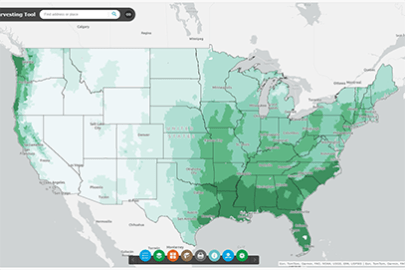
The potential for condensate capture from air-conditioning systems across the United States was studied by faculty and staff at the University of Georgia, and later published by ASHRAE.1 The researchers developed a method to estimate how much condensate can be collected annually, based on the location’s annual average dew point, cooling degree days, and rainfall. This method was applied to 47 cities in the U.S. and the results were mapped to ascertain patterns in the amount of condensate that can be captured in specific regions across the U.S. To evaluate this potential in greater detail, the Federal Energy Management Program (FEMP) applied the same estimating method to 64 additional sites across the U.S. The estimated condensate potential values for all 111 locales were then placed on the U.S. map, allowing for the creation of the areas that characterize the condensate capture potential across the country. This is shown in color-coded regions ranging from highest to lowest potential.
How to Use the Map
This map intends to provide an initial assessment of the feasibility of implementing condensate capture from air-conditioning systems at a given site. To determine if condensate capture should be considered for your site, locate your site on the map and determine the potential based on the color of your region. The potential to capture condensate is categorized as follows:
- Highest: Areas in the southeastern U.S. have high cooling loads during most of the year and high humidity, and therefore have the highest potential for condensate capture projects; and areas along the Gulf Coast, southern Florida, and Hawaii have particularly excellent potential.
- High: Areas from the Ohio River Valley to West Virginia and Mid-Atlantic regions, remaining areas of the South, and central Texas have high cooling loads and high summer humidity, giving them very good potential for capturing condensate.
- Medium-High: Areas in the northern Mid-Atlantic across to the central Midwest and coastal southern California have relatively hot and humid summers, giving them good potential for condensate capture projects.
- Medium: Areas along southern New England across the southern Great Lakes and into portions of the Midwest down to Texas have humid summers, giving them marginal potential for capturing condensate.
- Low and Lowest: Areas in the Western U.S. with low humidity or relatively low cooling demand have poor potential for condensate capture.
Considerations
The condensate capture potential presented on this map is based on local climate conditions of the selected cities. Within the regions, the condensate capture potential may vary due to local annual weather patterns. Other factors affecting the potential for condensate capture should also be considered when assessing the potential at a specific site; these include:
- Size of cooling system: Larger systems can potentially produce more condensate (depending on cooling system operation).
- Cooling system operation: Hours of operation and temperature set points will influence total hours of operation and condensate production.
Additional Resources
- FEMP's Best Management Practice #14: Alternative Water Sources
- FEMP's case study about a condensate capture project implemented by the U.S. Environmental Protection Agency
- Alliance for Water Efficiency's Introduction to Condensate Capture
1 Lawrence, T., Perry, J., Alsen, T. 2012. AHU Condensate Collection Economics: A Study of 47 U.S. Cities. ASHRAE Journal, May 2012, 18.